Massive Dust Cloud from Sahara Desert Set to Dim US Skies
In an unusual atmospheric phenomenon, a massive dust cloud originating from Africa’s Sahara Desert is making its way towards the United States, potentially causing a dimming effect on the sky this weekend. Meteorologists at AccuWeather have been closely monitoring several large dust clouds drifting over the Atlantic Ocean, with the potential to impact air quality and visibility across the Caribbean and southeastern regions of the US.
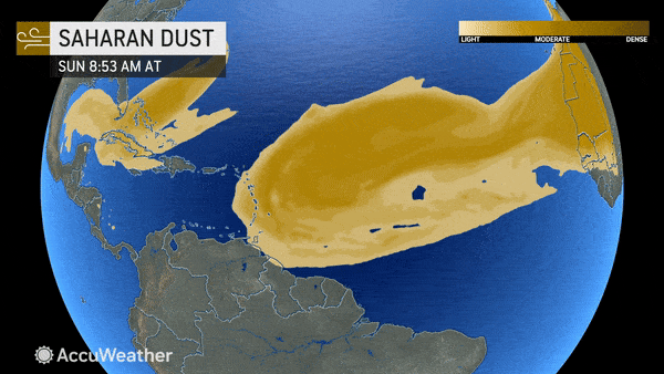
The density and expanse of the Saharan dust clouds are so significant that they were visible from space on Thursday, as observed by NOAA’s GOES-EAST weather satellite. The first dust cloud was spotted over the eastern Caribbean Sea and the Lesser Antilles, while a larger plume emerged off the coast of Africa. Although the presence of Saharan dust is not uncommon in the Atlantic basin, the location and magnitude of these dust clouds can vary throughout the season.
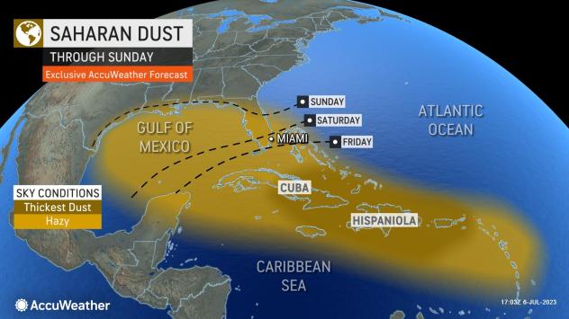
While the immediate wave of dust over the Caribbean Sea is expected to reach Florida by Saturday, extending towards coastal areas of Texas, Louisiana, Mississippi, and Alabama by Sunday, it may not be as extreme as the infamous “Godzilla dust cloud” that affected the Southeast in June 2020. Nonetheless, air quality could be impacted, and the sky may appear opaque due to the dust particles.
The arrival of the Saharan dust in Florida could also provide some relief from scorching temperatures experienced during the first week of July. The dust-filled sky may partially block sunlight, resulting in a slight temperature decrease. During the recent extended Independence Day weekend, temperatures soared into the mid- to upper 90s, with AccuWeather RealFeel Sun™ Temperatures nearing 120 degrees in certain areas.
Furthermore, a more substantial and robust Saharan dust cloud is currently being blown off the African coast and is expected to cross the Atlantic Ocean rapidly. Carried by the trade winds that move from east to west over the tropical Atlantic, this thicker dust cloud is projected to reach the eastern Caribbean by the end of the weekend, possibly approaching Florida by Tuesday. Such an event could worsen air quality in Puerto Rico, the Dominican Republic, Haiti, Cuba, and Florida.
During similar occurrences in recent history, Saharan dust has settled on car windows and reduced visibility to just a few miles. Individuals planning outdoor activities along the Gulf Coast in the coming week are advised to check the air quality forecast for their area due to the potential impact of the dust.
While Saharan dust can affect anyone, certain groups are more vulnerable to its health effects. The Centers for Disease Control and Prevention (CDC) highlight children, babies, older adults, and individuals with underlying lung conditions or chronic cardiopulmonary diseases as being particularly susceptible. The dust particles can irritate the skin and eyes and exacerbate symptoms of asthma and other respiratory and cardiovascular conditions.
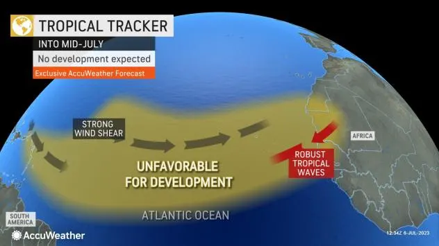
Interestingly, the widespread Saharan dust is currently suppressing tropical development across the Atlantic Ocean. Tropical waves, which often give rise to tropical storms and hurricanes, require a moist atmosphere for their formation. However, the presence of Saharan dust creates drier conditions, hindering the development of these weather systems.
With the Saharan dust expected to further spread across the Atlantic hurricane basin in the coming weeks, combined with disruptive winds over the ocean, it is unlikely that another tropical system will form in the near future. However, meteorologists at AccuWeather still anticipate an active Atlantic hurricane season, predicting the formation of 11 to 15 named tropical systems, with four to eight potentially becoming hurricanes. Of these, two to four are forecasted to directly impact the United States.
